Innovative Use of Remote Sensing Data
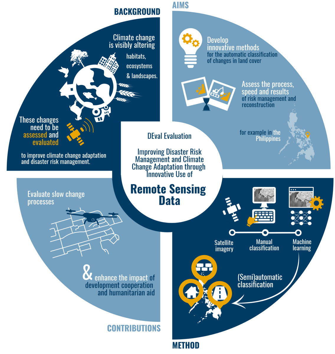
The use of remote sensing data in evaluations is an effective method for measuring the effects of climate change adaptation programmes and changes in the living environment of people. This includes, for example, the measurement of the scales of natural disasters or the expansion of infrastructure.
We are developing this method further in a targeted manner in cooperation with the Faculty of Geoinformation Science and Earth Observation of the University of Twente.

The impacts of climate change are addressed within large-scale development programs. However, the effects of these programs remain hard to verify using established evaluation methods. An innovative approach to answer these questions is the integration of new methods and methodological applications: The use of information derived from remote sensing data is a key mechanism to obtain in-depth information and add suitable instruments to the evaluators’ toolbox.
Remote sensing describes the collection and analysis of information of the earth’s surface by means of remotely operated collection platforms. Sensors attached to airplanes, satellites or drones capture spectral information, which are analyzed using geographic information systems (GIS). The integration of remote sensing data empowers evaluators to measure changes in the human environment, ranging from large-area phenomena such as deforestation, the extend of natural disasters, to small-scale changes, such as an assessment of household welfare or the development of regional infrastructure.

The German Institute for Development Evaluation utilizes the potentials of this promising approach pursuing the objective of using remote sensing information to measure the success of a rural development program in the Philippines dealing with the implementation of disaster risk management efforts. A comprehensive account of the disaster risk management efforts is generated by integrating information derived from different sources: high-resolution remote sensing data as well as survey data are processed and analyzes using sophisticated methodological approaches, such as machine learning techniques.
The development of these innovative methodological approaches is carried out in close cooperation with remote sensing experts from the Earth System Analysis Unit of the Faculty of Geo-Information Science and Earth Observation (ITC) of the University of Twente (Enschede, The Netherlands).
The methods developed during this project are later applied and refined in a follow-up evaluation examining the efforts of the German Development Cooperation in the field of climate change adaptation.
Team
- Dr Sven Harten Head of Competence Centre for Evaluation Methodology / Deputy Director
- Dr Gerald Leppert Former Senior Evaluator - Team Leader DEval
- Kai Rompczyk Evaluator
Contact
Dr Gerald Leppert
Phone: +49 (0)228 336907-968
E-mail: gerald.leppert@DEval.org
Dr Sven Harten
Phone: +49 (0)228 336907-950
E-mail: sven.harten@DEval.org
Publications
- Policy Brief: El árbol de decisiones según geodatos: Utilizando datos geográficos para evaluaciones
- Exploring the link between climate variability and mortality in sub-Saharan Africa
- Improving International Development Evaluation through Geospatial Data and Analysis
- Policy Brief: Der Geodaten-Entscheidungsbaum: Verwendung von Geodaten für Evaluierungen
- Policy Brief: The Geodata Decision Tree: Using Geodata for Evaluations
- Policy Briefs: From GIS to M&E: Extracting Value from Geodata for Evaluations
- Policy Brief: Von GIS zu M&E: Der Mehrwert geografischer Daten für Evaluierungen